INDIA GEOSPATIAL EDUCATION

An initiative of the National Geospatial Program (erstwhile NRDMS, the Department of Science and Technology (DST), Government of India and Department of Geoinformatics at the Institute of Environment Education and Research, Bharati Vidyapeeth Deemed University, Pune.

INDIA GEOSPATIAL EDUCATION

An initiative of the National Geospatial Program (erstwhile NRDMS, the Department of Science and Technology (DST), Government of India and Department of Geoinformatics at the Institute of Environment Education and Research, Bharati Vidyapeeth Deemed University, Pune.

INDIA GEOSPATIAL EDUCATION

An initiative of the National Geospatial Program (erstwhile NRDMS, the Department of Science and Technology (DST), Government of India and Department of Geoinformatics at the Institute of Environment Education and Research, Bharati Vidyapeeth Deemed University, Pune.

INDIA GEOSPATIAL EDUCATION

An initiative of the National Geospatial Program (erstwhile NRDMS, the Department of Science and Technology (DST), Government of India and Department of Geoinformatics at the Institute of Environment Education and Research, Bharati Vidyapeeth Deemed University, Pune.

INDIA GEOSPATIAL EDUCATION

An initiative of the National Geospatial Program (erstwhile NRDMS, the Department of Science and Technology (DST), Government of India and Department of Geoinformatics at the Institute of Environment Education and Research, Bharati Vidyapeeth Deemed University, Pune.

The portal contains a large bank of tutorials with data based on geographical information systems, remote sensing, spatial analysis, WebGIS, and other topics.

Welcome to IGET India Geospatial Education

This portal is an initiative of the National Geospatial Program (erstwhile NRDMS), Department of Science and Technology (DST), Government of India and Department of Geoinformatics, Institute of Environment Education and Research, Bharati Vidyapeeth Deemed University, Pune

The report of the Task Force of the Ministry of Human Resource Development, Government of India (2014) on geospatial education in the country has recommended that the nation must enable itself in this technology area. In this regard, a national portal for Capacity Building for Geospatial Science and Technology has been developed by the Bharati Vidyapeeth University, Institute of Environment Education and Research, Pune support by the DST, Government of India.

Overall Tutorials

60
+

Summer/Winter Schools

100
+

Participants Trained

5000
+

India’s Journey Of Sustainable Economic Growth

In India’s recent journey of sustainable economic growth, the geospatial information has emerged asan effective enabler to support good governance, sustainable development goals and empowerment of its citizens. In India’s evolving geospatial ecosystem, the current focus is on improving the publicness in the provision of geospatial data and information through institutional strengthening for enhancing the performance of organizations.

Capacity refers to the ability of individuals and organizations to make and implement decisions and perform functions in an effective, efficient and sustainable manner. Capacity building is an ongoing process and involves changing attitudes, imparting technical knowledge and developing skills while maximizing the benefits of participation, knowledge exchange and ownership.

Harnessing Geospatial Intelligence: Transforming India's Digital Landscape

"In an era marked by unprecedented technological advancements, the significance of geospatial information cannot be overstated. India's ambitious digital programs, spanning domains from smart cities to precision agriculture, underscore the indispensable role of geospatial intelligence. From the innovative Smart Cities Mission to the transformative Digital India initiative, geospatial data serves as the linchpin, enabling informed decision-making and driving sustainable development. As India forges ahead in its journey towards becoming a digital powerhouse, the harnessing of geospatial data emerges as a cornerstone of this transformative endeavour.

Recognizing the importance, the National Geospatial Program (NGP) under of Department of Science and Technology, Government of India, has been at the forefront of empowering individuals and organizations through a series of transformative initiatives. These geospatial capacity-building programs facilitate the development of geospatial expertise essential for navigating the complexities of the modern world.

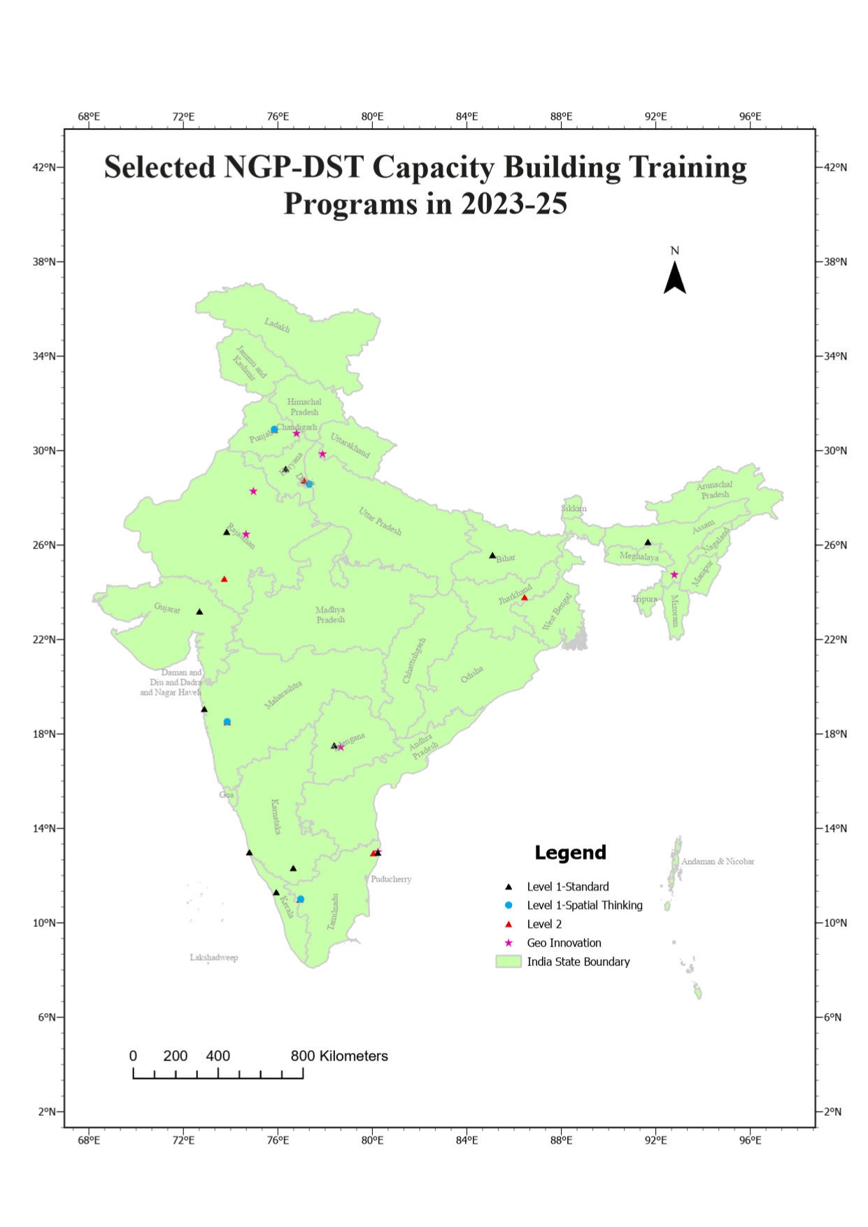
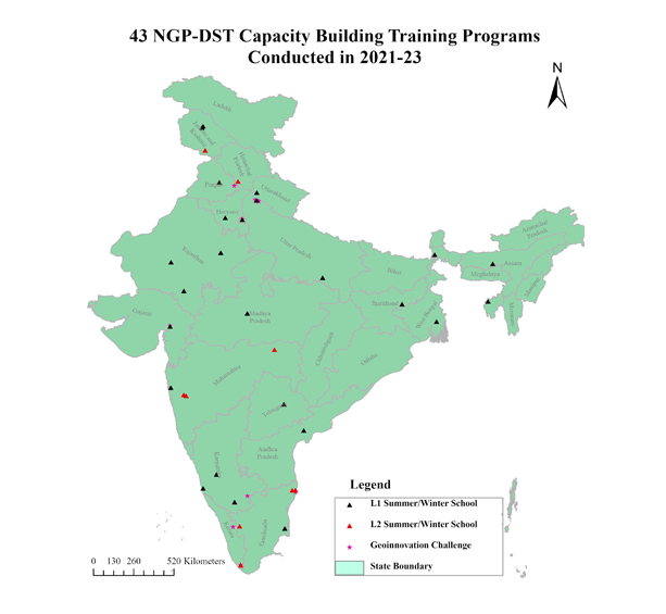
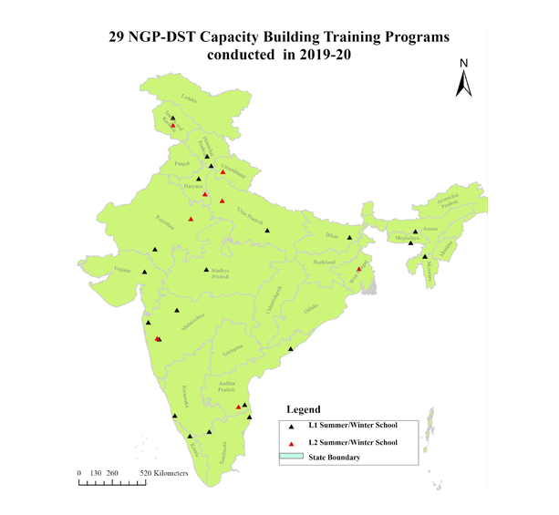
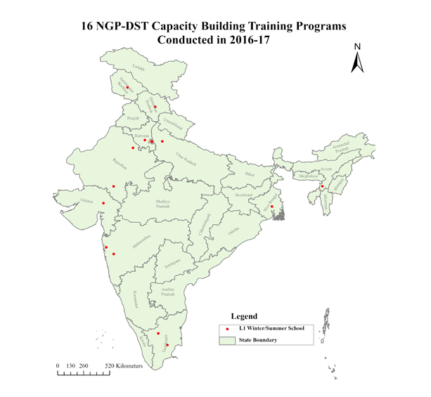
Over the past decade, the National Geospatial Program has conducted three-week summer and winter schools across the length and breadth of the country, nurturing a cadre of over 5500 participants in geospatial science and technology. These immersive programs, spanning diverse thematic areas, have equipped participants with the knowledge and skills needed to tackle contemporary challenges and drive innovation in geospatial domains. Along with these three-week programs, a specific program focusing on the generation of new ideas and entrepreneurial spirit in the realm of geospatial science and technology among the youth - the 'Geo-innovation Challenge' program - has been initiated.

Aligning with the educational objectives outlined in the New Geospatial Policy 2022 of the Government of India, which emphasizes the importance of popularizing this technology among school children, several workshops across the country with the State Council for Education, Research and Training (SCERTs) are being organized. These workshops aimed to raise knowledge of geospatial technologies and its applications amongst the school-teachers who can be nodes for inculcating the spatial thinking in the young minds.

In a significant step towards curriculum development and training standardization, the Department of Science and Technology supports an R&D project at the Institute of Environment Education and Research, Bharati Vidyapeeth Deemed University, Pune. This collaboration has resulted in the creation of a national portal on Geospatial Technology, serving as a repository of knowledge and resources for aspiring geospatial professionals. With an extensive database of tutorials covering GIS, Remote Sensing, Spatial Analysis, the portal (dst-iget) has become a cornerstone of capacity-building efforts, attracting nearly 8000 visitors every month.

As we chart a course towards a future defined by innovation, inclusivity, and sustainability, the efforts of the National Geospatial Program serve as a guiding light, illuminating the path for aspiring geospatial professionals. Together, let us embark on this journey of exploration and discovery, leveraging the power of geospatial information to build a better tomorrow for generations to come”.

Head, National Geospatial Division, Department of Science and Technology (DST), Government of India

Tutorials

The portal contains large bank theme-specific tutorials on geospatial technologies for marine sciences, disaster management, watershed management, etc. developed by the Principal Investigators from organizations who have been part of conducting the summer/winter schools in geospatial science and technology.

GIS

Welcome to our QGIS tutorials! Whether you're a novice or a seasoned geospatial enthusiast, these step-by-step guides will empower you to harness the power of Quantum Geographic Information System (QGIS) for mapping, analysis, and visualization. Let's dive into the world of spatial data!

Imagery and Remote Sensing

Explore the power of open-source SAGA software to manipulate, analyze, and extract valuable information from satellite and aerial imagery. Unlock the potential of satellite and aerial imagery for environmental monitoring, urban planning, and more. Learn to extract valuable insights from the Earth's surface using cutting-edge techniques. Join us on this visual journey!

Spatial Analysis

Dive into the world of geospatial analysis with tools like QGIS, SAGA, Fragstats, SWAT, and others, as we unravel their capabilities for understanding and addressing spatial challenges.

Advanced Geospatial Analysis

Explore cutting-edge techniques to unravel complex spatial insights, enhancing your ability to navigate today's data-rich landscapes.

Data Management

Delve into the world of geospatial database management with our tutorials, centered on robust tools like PostgreSQL and PostGIS. Discover how to efficiently organize, query, and analyze spatial data, unleashing the full potential of geospatial information systems.

The winter School in 2019 was one of the best training programs I ever attended in my life because it was only after the training that I could initiate a PG Diploma Programme in Geoinformatics and Remote Sensing at our University

Dr Prabhudan Charan

Assistant Professor, Department of Environmental Science, Maharaja Ganga Singh University, Bikaner, Rajasthan Level -I, Winter School, 2019

We use geospatial technology for various applications like mapping the rubber plantations, drought monitoring, agro-climatic suitability analysis, climate -change related studies like floods and landslides susceptibility mapping. After attending the winter school in 2016 , I could understand the importance of this technology in soil analysis and we could initiate work in WebGIS development and android applications for fertilizer recommendations for rubber farmers.

Pradeep Balan

Scientist, Remote Sensing, Rubber institute , Kerala Level -I , Winter School, 2016

The training conducted by BVIEER and DST was very beneficial to us. We are applying the training in our day-to-day work. We have undertaken a programme where we are trying to monitor the pollution levels inside the forest.

Dr. Sudipto Chatterjee

Head and Associate Professor, Department of Regional Water Studies, TERI School of Advanced Studies, New Delhi Level -II, Winter School, 2021

The winter school helped us to learn how to assess and use the Remote Sensing data for Ecosystem conservation and management , assess forest-fire changes , species distribution and modelling through open source GIS , Fragstats, and Google Earth Engine. Faculty were supportive and answered queries throughout the program anytime . It helped me get ideas of using GIS to analyse access and benefit-sharing mechanisms as mandated by the Biodiversity Act , 2002.

Dr. Srirama Ramanujam

Young Professional II, National Biodiversity Authority (NBA) , Chennai Level -II , Winter School, 2021

I am immensely grateful for the prize and it will certainly work as a motivation to develop the monitoring system based on the idea mapping the spread of pandemic in the country using sewage water. Thanks to DST for conducting the Geo Innovation Challenge and looking forward for more in the future.

Dr Brahma Vishwakarma

IISc Bangalore, First Prize, GeoInnovation Challenge, 2021