Welcome to IGET India Geospatial Education
This portal is an initiative of the National Geospatial Program (erstwhile NRDMS), Department of Science and Technology (DST), Government of India and Department of Geoinformatics, Institute of Environment Education and Research, Bharati Vidyapeeth Deemed University, Pune
The report of the Task Force of the Ministry of Human Resource Development, Government of India (2014) on geospatial education in the country has recommended that the nation must enable itself in this technology area. In this regard, a national portal for Capacity Building for Geospatial Science and Technology has been developed by the Bharati Vidyapeeth University, Institute of Environment Education and Research, Pune support by the DST, Government of India.
The portal contains a large bank of tutorials with data based on geographical information systems, remote sensing, spatial analysis, WebGIS, and other topics. These include theme specific tutorials on geospatial technologies for marine sciences, disaster management, watershed management, etc. developed by the Principal Investigators from organisations who have been part of conducting the summer/winter schools in geospatial science and technology. The bank of tutorials are continuously being updated. The portal also consists of a data base of resource persons as well as the outline of three week training programme. The portal is being used regularly and accessed by almost 8000 people per month. This may be viewed through the website: http://dst-iget.in. We hope these efforts would be of immense help to the new trainees for upscaling their knowledge in geospatial science and technologies.
In order to develop the course /training module on capacity building in Geospatial Technologies, DST has supported an R&D project to Institute of Environment Education and Research, Bharati Vidyapeeth University, Pune. In this regard, a national portal on Geospatial Technology was also developed by them. A large bank of tutorials based on GIS, Remote Sensing, Spatial Analysis WebGIS sectors have been uploaded to the portal. It consists of data base of resource persons as well as the outline of three week training programme. The portal is being used regularly and accessed by almost 8000 people per month. This may be viewed through the website : www.dst-iget.in. I hope the efforts made by this group would be of immense help to the new trainees for upscaling their knowledge in Geospatial Technologies.
India’s Journey Of Sustainable Economic Growth
In India’s recent journey of sustainable economic growth, the geospatial information has emerged asan effective enabler to support good governance, sustainable development goals and empowerment of its citizens. In India’s evolving geospatial ecosystem, the current focus is on improving the publicness in the provision of geospatial data and information through institutional strengthening for enhancing the performance of organizations.
Capacity refers to the ability of individuals and organizations to make and implement decisions and perform functions in an effective, efficient and sustainable manner. Capacity building is an ongoing process and involves changing attitudes, imparting technical knowledge and developing skills while maximizing the benefits of participation, knowledge exchange and ownership. Recognizing the above needs, the National Geospatial Program (erstwhile NRDMS) of the Department of
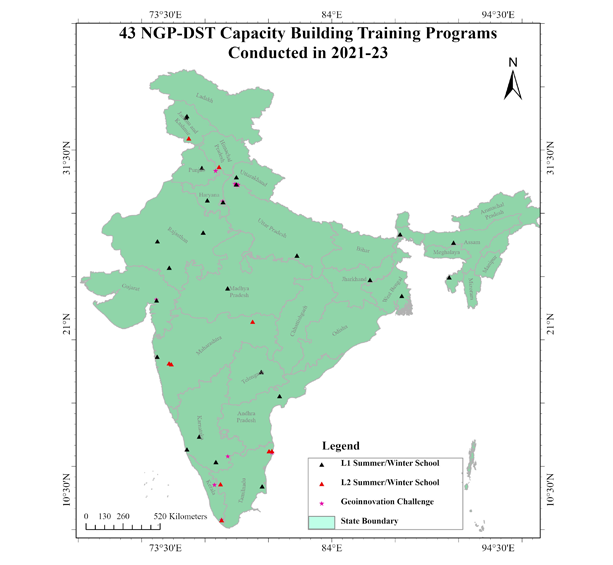
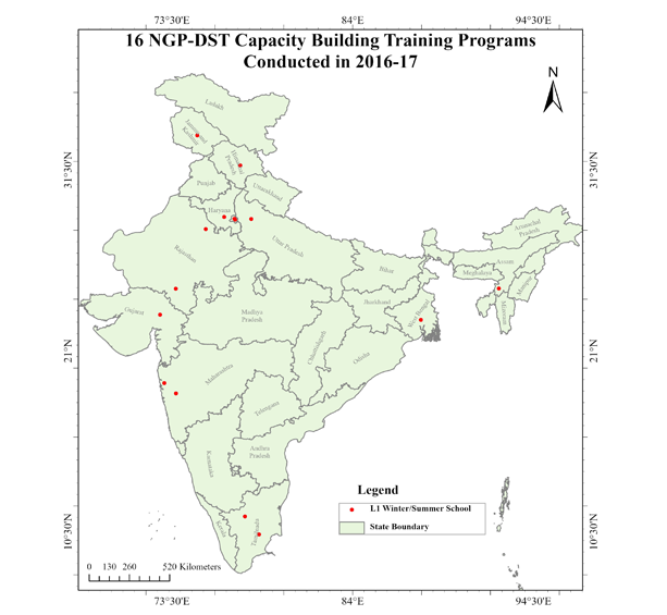
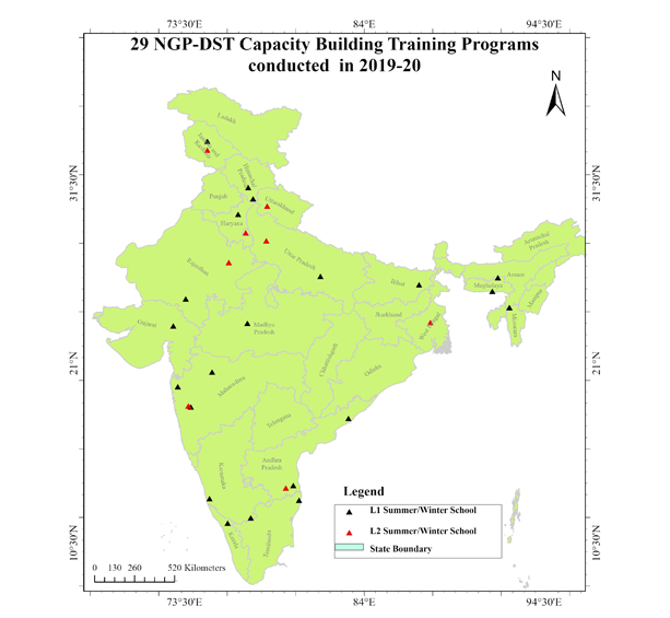
Science and Technology, Government of India is conducting summer/winter schools over last a decade to develop national capacity for geospatial science and technology development through diverse programs in collaboration with various partner organizations across the country. So far total over 5000 participants have been trained all over the country at various levels of geospatial science and technology through 166 summer/winter schools in geospatial science and technology. From this year two new initiatives viz. ‘Geo-innovation Challenge’ for harnessing new ideas in Geospatial Science, Technology and entrepreneurship and a special call for SC/ ST category under 21 Day summer/winter schools in geospatial science and technology (Level-1).have been launched.
In order to develop the course /training module on capacity building in Geospatial Technologies, DST has supported an R&D project to Institute of Environment Education and Research, Bharati Vidyapeeth University, Pune. In this regard, a national portal on Geospatial Technology was also developed by them. A large bank of tutorials based on GIS, Remote Sensing, Spatial Analysis WebGIS sectors have been uploaded to the portal. It consists of data base of resource persons as well as the outline of three week training programme. The portal is being used regularly and accessed by almost 8000 people per month. This may be viewed through the website : www.dst-iget.in. I hope the efforts made by this group would be of immense help to the new trainees for upscaling their knowledge in Geospatial Technologies.
National Geospatial Program (erstwhile NRDMS)
Department of Science & Technology
Government of India, New Delhi
The winter School in 2019 was one of the best training programs I ever attended in my life because it was only after the training that I could initiate a PG Diploma Programme in Geoinformatics and Remote Sensing at our University
Dr Prabhudan Charan
Assistant Professor, Department of Environmental Science, Maharaja Ganga Singh University, Bikaner, Rajasthan Level -I, Winter School, 2019
We use geospatial technology for various applications like mapping the rubber plantations, drought monitoring, agro-climatic suitability analysis, climate -change related studies like floods and landslides susceptibility mapping. After attending the winter school in 2016 , I could understand the importance of this technology in soil analysis and we could initiate work in WebGIS development and android applications for fertilizer recommendations for rubber farmers.
Pradeep Balan
Scientist, Remote Sensing, Rubber institute , Kerala Level -I , Winter School, 2016
The training conducted by BVIEER and DST was very beneficial to us. We are applying the training in our day-to-day work. We have undertaken a programme where we are trying to monitor the pollution levels inside the forest.
Dr. Sudipto Chatterjee
Head and Associate Professor, Department of Regional Water Studies, TERI School of Advanced Studies, New Delhi Level -II, Winter School, 2021
The winter school helped us to learn how to assess and use the Remote Sensing data for Ecosystem conservation and management , assess forest-fire changes , species distribution and modelling through open source GIS , Fragstats, and Google Earth Engine. Faculty were supportive and answered queries throughout the program anytime . It helped me get ideas of using GIS to analyse access and benefit-sharing mechanisms as mandated by the Biodiversity Act , 2002.
Dr. Srirama Ramanujam
Young Professional II, National Biodiversity Authority (NBA) , Chennai Level -II , Winter School, 2021
I am immensely grateful for the prize and it will certainly work as a motivation to develop the monitoring system based on the idea mapping the spread of pandemic in the country using sewage water. Thanks to DST for conducting the Geo Innovation Challenge and looking forward for more in the future.